Track and time this hike using a mobile device!
TRACK AND TIME YOUR HIKE
Stawamus Chief Third Peak
 Directions to Stawamus Chief Third Peak
 Download offline KML trail map of Stawamus Chief Third Peak

Add your own photos
Shannon Falls Provincial Park, Squamish
49.671900, -123.159867
12°c Few Clouds Humidity: 51% Sunset: 8:10 pm
Track and hike this trail on your mobile device!
Total Distance
(One Direction)
(One Direction)
Total Ascent
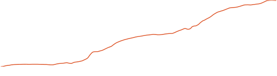
Elevation Profile
Trail Description
Awesome vistas of the Howe Sound, and the Coast Mountains to the east.
Photos of Stawamus Chief Third Peak
There are no photos of this trail added yet. Add your own photos
There are no photos of this trail added yet.
Tags
Download Free KML Trail Map for Stawamus Chief Third Peak
 Stawamus Chief Third Peak is equipped with a free downloadable offline trail map that can used in Google Earth, Google Maps/KML enabled cell-phone or in a GPS device.
Download KML trail map
Stawamus Chief Third Peak is equipped with a free downloadable offline trail map that can used in Google Earth, Google Maps/KML enabled cell-phone or in a GPS device.
Download KML trail map
Trails near Stawamus Chief Third Peak
Stawamus Chief First Peak
Stawamus Chief Second Peak
Sea to Summit Trail 80 meters away
Sea to Sky Trail First Leg 1.4 km away
Deeks Lake Trail 15.3 km away
Top Trail Times
| # | Hiker | Date | Start Time | Duration |
Comments